Global Terrestrial Laser Scanning Market
Tamanho do mercado em biliões de dólares
CAGR :
% 
 USD
4.82 Billion
USD
9.10 Billion
2024
2032
USD
4.82 Billion
USD
9.10 Billion
2024
2032
| 2025 –2032 | |
| USD 4.82 Billion | |
| USD 9.10 Billion | |
|
|
|
|
Segmentação do mercado global de escaneamento a laser terrestre, por tipo (scanner de mudança de fase, scanner baseado em pulso, scanner móvel e triangulação óptica), solução (sistema de escaneamento a laser terrestre e serviços de escaneamento a laser terrestre), tipo de laser (diodo, fibra e estado sólido), produtos (escaneamento a laser terrestre dinâmico e escaneamento a laser terrestre estacionário/estático), princípios (scanner galvanômetro, scanner poligonal, scanner de eixo e outros), mapeamentos (scanner de câmera, scanner híbrido, scanner panorâmico e outros), aplicação (modelagem de informações da construção (BIM), topografia, pesquisa e engenharia e outros), uso final (industrial, instalações nucleares, energia, residencial, petróleo e gás, indústria naval e química) - tendências e previsões do setor até 2032
Qual é o tamanho e a taxa de crescimento do mercado global de escaneamento a laser terrestre?
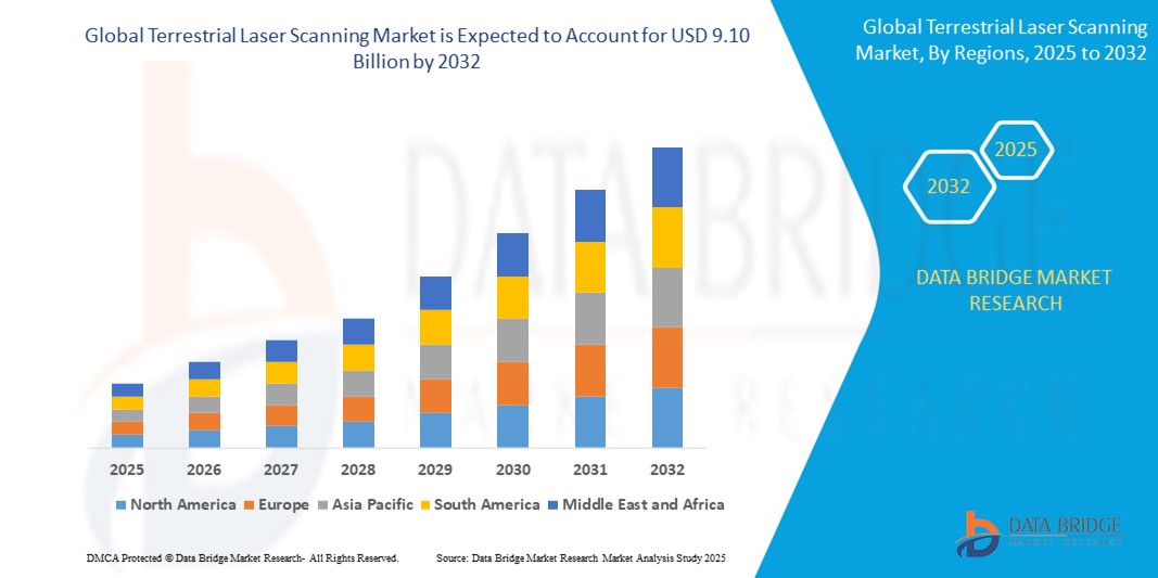
- O tamanho do mercado global de escaneamento a laser terrestre foi avaliado em US$ 4,82 bilhões em 2024 e deve atingir US$ 9,10 bilhões até 2032 , com um CAGR de 8,25% durante o período previsto.
- O mercado de escaneamento a laser terrestre está experimentando um crescimento significativo, impulsionado pelos avanços na tecnologia e pela crescente demanda por coleta precisa de dados 3D em vários setores
- Métodos recentes incluem a integração de imagens de alta resolução e software avançado que aprimora as capacidades de processamento e análise de dados. Por exemplo, o uso de sistemas móveis de escaneamento a laser permite a captura de dados mais rápida e eficiente em ambientes complexos, como áreas urbanas e canteiros de obras.
Quais são os principais resultados do mercado de escaneamento a laser terrestre?
- O mercado também está em expansão devido ao aumento de aplicações em setores como mineração, silvicultura e documentação do patrimônio cultural. Com as organizações reconhecendo cada vez mais o valor de dados espaciais precisos e detalhados, o mercado de escaneamento a laser terrestre deverá crescer a um ritmo robusto, com previsões sugerindo uma taxa de crescimento anual composta (CAGR) significativa nos próximos anos. Esse crescimento reflete uma tendência mais ampla em direção à transformação digital e à tomada de decisões baseada em dados em diversos setores.
- A América do Norte dominou o mercado de escaneamento a laser terrestre, com a maior participação na receita, de 38,6% em 2024, impulsionada pela ampla adoção em projetos de modernização de infraestrutura, automação industrial e mapeamento de alta precisão. O setor de construção civil maduro da região e a forte ênfase na integração tecnológica estão impulsionando a ampla implementação em todas as aplicações.
- A região da Ásia-Pacífico deverá crescer a uma taxa composta de crescimento anual (CAGR) de 13,5% entre 2025 e 2032, impulsionada por investimentos massivos em cidades inteligentes, infraestrutura de transporte e digitalização industrial. Países como China, Índia, Japão e Coreia do Sul estão adotando rapidamente tecnologias de escaneamento a laser para planejamento urbano, monitoramento de construção e mapeamento de serviços públicos como parte de suas agendas de transformação urbana.
- O segmento Phase-Shift Scanner dominou o mercado com a maior participação de receita de 36,4% em 2024, devido à sua capacidade de capturar dados de alta resolução rapidamente e com precisão excepcional, tornando-o ideal para projetos arquitetônicos e de infraestrutura detalhados.
Escopo do Relatório e Segmentação do Mercado de Varredura a Laser Terrestre
|
Atributos |
Principais insights de mercado sobre escaneamento a laser terrestre |
|
Segmentos abrangidos |
|
|
Países abrangidos |
América do Norte
Europa
Ásia-Pacífico
Oriente Médio e África
Ámérica do Sul
|
|
Principais participantes do mercado |
|
|
Oportunidades de mercado |
|
|
Conjuntos de informações de dados de valor agregado |
Além dos insights sobre cenários de mercado, como valor de mercado, taxa de crescimento, segmentação, cobertura geográfica e principais participantes, os relatórios de mercado selecionados pela Data Bridge Market Research também incluem análises aprofundadas de especialistas, análises de preços, análises de participação de marca, pesquisas com consumidores, análises demográficas, análises da cadeia de suprimentos, análises da cadeia de valor, visão geral de matérias-primas/consumíveis, critérios de seleção de fornecedores, análise PESTLE, análise de Porter e estrutura regulatória. |
Qual é a principal tendência no mercado de escaneamento a laser terrestre?
“ Integração de IA e processamento de dados em tempo real para maior eficiência de digitalização ”
- Uma tendência líder no mercado de escaneamento a laser terrestre (TLS) é a integração de inteligência artificial (IA) e análise de dados em tempo real para melhorar a precisão, automação e velocidade do escaneamento em indústrias de alta demanda
- Os sistemas TLS de nova geração agora contam com automação alimentada por IA para registrar automaticamente nuvens de pontos, filtrar ruídos e detectar anomalias em tempo real, reduzindo o tempo de processamento manual.
- Grandes players como a FARO Technologies e a Trimble estão implementando scanners inteligentes que podem aprender com varreduras anteriores, adaptar-se a variáveis ambientais e fornecer resultados consistentes
- A integração com plataformas baseadas em nuvem e sistemas BIM permite transferência de dados contínua, modelagem colaborativa e monitoramento remoto, tornando o TLS central para projetos de gêmeos digitais e infraestrutura inteligente
- Esses desenvolvimentos são especialmente vitais na construção, mineração e transporte, onde ambientes dinâmicos exigem ferramentas de digitalização inteligentes e responsivas.
- A mudança para TLS habilitado para IA está redefinindo o setor ao aumentar a produtividade operacional, a precisão dos dados e a sincronização de vários dispositivos em projetos de grande escala.
Quais são os principais impulsionadores do mercado de escaneamento a laser terrestre?
- A crescente adoção de BIM (Building Information Modeling) e tecnologias de gêmeos digitais na construção, infraestrutura e planejamento urbano está aumentando significativamente a demanda por sistemas TLS de alta resolução
- Em maio de 2024, a Leica Geosystems lançou uma nova unidade TLS com autocalibração automatizada, reduzindo o tempo de configuração no local e melhorando a qualidade da digitalização em condições climáticas variáveis.
- Os dispositivos TLS são cruciais para aplicações que exigem medições 3D de campo completo e sem contato , especialmente em áreas como forense, arqueologia e levantamento de túneis
- A necessidade de dados topográficos precisos para expansão de rodovias, cidades inteligentes e desenvolvimento ferroviário está acelerando a adoção do TLS entre agências e contratantes do setor público
- O crescimento em automação industrial e robótica está criando novos casos de uso para TLS em inspeção de componentes, mapeamento de caminho robótico e automação de armazém
- Os avanços na portabilidade do scanner, na duração da bateria e no software de fácil utilização estão expandindo o alcance da tecnologia além dos inspetores tradicionais para arquitetos, engenheiros e gerentes de instalações.
Qual fator está desafiando o crescimento do mercado de escaneamento a laser terrestre?
- Um desafio fundamental é o elevado custo inicial dos scanners laser terrestres e do software relacionado, o que pode restringir a adopção entre pequenas e médias empresas
- Dispositivos como o RIEGL VZ-400i e o Leica RTC360 oferecem recursos poderosos, mas exigem investimentos significativos em hardware, treinamento e ferramentas de pós-processamento
- Outra barreira é a complexidade do processamento de dados, uma vez que nuvens de pontos em larga escala exigem recursos computacionais substanciais e pessoal treinado para análise e modelagem.
- Fatores ambientais como chuva, neblina ou superfícies reflexivas podem afetar a qualidade da digitalização, exigindo digitalizações repetidas ou equipamento suplementar para garantir a precisão
- A conformidade com os regulamentos de tratamento de dados e a proteção de dados de projetos baseados em nuvem são preocupações crescentes, especialmente para aplicativos de infraestrutura e defesa
- Para permitir uma adoção mais ampla, os fornecedores devem se concentrar em modelos econômicos, plataformas de treinamento aprimoradas e interoperabilidade aprimorada com ecossistemas de software existentes
Como o mercado de escaneamento a laser terrestre é segmentado?
O mercado é segmentado com base no tipo, solução, tipo de laser, produtos, princípios, mapeamentos, aplicação e uso final.
• Por tipo
Com base no tipo, o mercado de escaneamento a laser terrestre é segmentado em Scanner de Deslocamento de Fase, Scanner Baseado em Pulso, Scanner Móvel e Triangulação Óptica. O segmento de Scanner de Deslocamento de Fase dominou o mercado com a maior participação na receita, 36,4% em 2024, devido à sua capacidade de capturar dados de alta resolução com rapidez e precisão excepcional, tornando-o ideal para projetos detalhados de arquitetura e infraestrutura.
O segmento de scanners móveis deverá testemunhar o CAGR mais rápido de 2025 a 2032, impulsionado por sua portabilidade, facilidade de implantação e adequação a ambientes complexos e dinâmicos, como mapeamento urbano e canteiros de obras.
• Por Solução
Com base na solução, o mercado é segmentado em sistemas de escaneamento a laser terrestre e serviços de escaneamento a laser terrestre. O segmento de sistemas de escaneamento a laser terrestre representou a maior participação de mercado, de 69,1% em 2024, impulsionado pela forte demanda por soluções integradas e focadas em hardware nos setores de construção, mineração e manufatura.
Espera-se que o segmento de Serviços de Escaneamento a Laser Terrestre cresça no CAGR mais rápido durante o período previsto, apoiado pela crescente demanda por escaneamento como serviço, consultoria e processamento de dados em projetos que exigem soluções de curto prazo ou terceirizadas.
• Por tipo de laser
Com base no tipo de laser, o mercado é segmentado em diodo, fibra e estado sólido. O segmento de laser de fibra deteve a maior participação de mercado, com 47,2% da receita em 2024, devido à sua eficiência, precisão e adequação para escanear superfícies metálicas e industriais em diversas condições.
Espera-se que o segmento de laser de diodo registre o CAGR mais rápido de 2025 a 2032, devido à sua compactação, custo-benefício e uso crescente em sistemas de escaneamento a laser terrestre leves e portáteis.
• Por produtos
Com base nos produtos, o mercado é categorizado em Escaneamento a Laser Terrestre Dinâmico e Escaneamento a Laser Terrestre Estacionário/Estático. O segmento de Escaneamento a Laser Terrestre Estacionário/Estático dominou, com uma participação de receita de 58,5% em 2024, pois oferece escaneamentos estáveis e de alta precisão em projetos de grande escala, como documentação de edifícios e mapeamento arqueológico.
O segmento de escaneamento terrestre dinâmico a laser deve crescer com o maior CAGR durante o período previsto, graças à sua aplicação em mapeamento móvel, veículos autônomos e coleta de dados geoespaciais em rápida evolução.
• Por Princípios
Com base em princípios, o mercado de escaneamento a laser terrestre é segmentado em Scanner Galvanômetro, Scanner Poligonal, Scanner de Eixo e outros. O segmento de Scanner Galvanômetro deteve a maior participação na receita, 33,8% em 2024, sendo favorecido por sua capacidade de escaneamento de alta velocidade e precisão em aplicações como inspeções industriais e levantamentos topográficos.
Espera-se que o segmento de scanners poligonais cresça na CAGR mais rápida de 2025 a 2032, impulsionado por seus amplos ângulos de varredura e adaptabilidade em ambientes de alto rendimento.
• Por Mapeamentos
Com base nos tipos de mapeamento, o mercado é segmentado em Scanner de Câmera, Scanner Híbrido, Scanner Panorâmico e outros. O segmento de Scanner Panorâmico liderou o mercado em 2024, com uma participação de receita de 35,2%, graças aos seus recursos de digitalização de 360 graus, cruciais para imagens de grandes áreas e modelagem de gêmeos digitais.
A previsão é de que o segmento de scanner híbrido cresça com o maior CAGR, pois combina recursos de diversas tecnologias de digitalização, aumentando a versatilidade e a precisão para projetos multidomínio.
• Por aplicação
Com base na aplicação, o mercado de escaneamento a laser terrestre é segmentado em Modelagem de Informações da Construção (BIM), Topografia, Pesquisa e Engenharia, entre outros. O segmento de Modelagem de Informações da Construção (BIM) dominou, com a maior participação na receita, de 39,6% em 2024, impulsionado pela crescente adoção em construção inteligente, reforma e monitoramento de infraestrutura.
O segmento de Pesquisa e Engenharia deverá registrar o crescimento mais rápido, devido ao uso crescente em projetos de P&D acadêmicos, arqueológicos e industriais.
• Até o uso final
Com base no uso final, o mercado é categorizado em Industrial, Instalações Nucleares, Energia, Residencial, Petróleo e Gás, Indústria Naval e Química. O segmento Industrial conquistou a maior fatia de mercado, com 28,9% em 2024, visto que a varredura a laser é amplamente utilizada em controle de qualidade, planejamento de instalações e calibração de máquinas.
Espera-se que o segmento de instalações nucleares cresça com o maior CAGR de 2025 a 2032, apoiado pela necessidade de varredura segura, remota e altamente precisa em áreas perigosas e de acesso restrito.
Qual região detém a maior fatia do mercado de escaneamento a laser terrestre?
- A América do Norte dominou o mercado de escaneamento a laser terrestre, com a maior participação na receita, de 38,6% em 2024, impulsionada pela ampla adoção em projetos de modernização de infraestrutura, automação industrial e mapeamento de alta precisão. O setor de construção civil maduro da região e a forte ênfase na integração tecnológica estão impulsionando a ampla implementação em todas as aplicações.
- Os EUA e o Canadá são mercados líderes, apoiados por investimentos governamentais em sistemas de transporte inteligentes, inspeção de serviços públicos e práticas de construção baseadas em BIM.
- Os mandatos regulatórios para segurança, documentação de ativos e arquivamento digital estão promovendo ainda mais a implantação de scanners a laser terrestres em projetos federais e comerciais.
Visão do mercado de escaneamento a laser terrestre dos EUA
Os EUA lideram o mercado norte-americano, impulsionados pela crescente demanda em setores como engenharia civil, geração de energia e defesa. O TLS é amplamente utilizado para inspeção de pontes, análise de locais e modelagem de instalações. A adoção é ainda mais potencializada pela integração com drones, análises de IA e plataformas de dados baseadas em nuvem, aumentando a escalabilidade e o ROI.
Visão geral do mercado de escaneamento terrestre a laser no Canadá
O mercado canadense está em constante crescimento devido à sua ênfase no desenvolvimento urbano sustentável e no monitoramento remoto de infraestrutura. Aplicações em oleodutos e gasodutos, mineração e preservação histórica são importantes contribuintes. Financiamento para inovação apoiado pelo governo e mandatos de digitalização 3D em projetos ambientais e de patrimônio histórico estão fortalecendo a adoção nacional do TLS.
Qual região tem o crescimento mais rápido no mercado de escaneamento a laser terrestre?
A região da Ásia-Pacífico deverá crescer a uma taxa composta de crescimento anual (CAGR) de 13,5% entre 2025 e 2032, impulsionada por investimentos massivos em cidades inteligentes, infraestrutura de transporte e digitalização industrial. Países como China, Índia, Japão e Coreia do Sul estão adotando rapidamente tecnologias de escaneamento a laser para planejamento urbano, monitoramento de construção e mapeamento de serviços públicos como parte de suas agendas de transformação urbana. A crescente presença de fornecedores locais, a crescente conscientização sobre os benefícios da automação e as iniciativas governamentais de infraestrutura estão acelerando a implantação do TLS nos setores público e privado.
Visão do mercado de escaneamento a laser terrestre da China
A China lidera a região Ásia-Pacífico, apoiada por suas metas de desenvolvimento de infraestrutura digital em iniciativas como "Nova Infraestrutura" e "Cidade Inteligente da China". O TLS é amplamente adotado em megaprojetos envolvendo rodovias, sistemas de metrô e criação de gêmeos digitais. Fabricantes nacionais de scanners oferecem soluções econômicas, impulsionando a acessibilidade regional.
Visão do mercado de escaneamento a laser terrestre do Japão
O foco do Japão em segurança sísmica e engenharia de alta precisão impulsiona o uso do TLS em transporte, serviços públicos e construção. A adoção é forte em modelagem ferroviária, inspeções de túneis e monitoramento da saúde estrutural. A integração com robótica e sistemas autônomos de levantamento reforça ainda mais as aplicações tecnologicamente avançadas do Japão.
Visão do mercado de escaneamento a laser terrestre da Índia
A Índia está emergindo como um polo de crescimento devido à expansão de iniciativas de cidades inteligentes, desenvolvimento imobiliário e planejamento de corredores industriais. O TLS está ganhando força em mapeamento de rodovias, requalificação urbana e documentação de ativos. Campanhas governamentais como "Índia Digital" e "Make in India" estão impulsionando a adoção do TLS em todos os setores e regiões.
Quais são as principais empresas no mercado de escaneamento a laser terrestre?
O setor de escaneamento a laser terrestre é liderado principalmente por empresas bem estabelecidas, incluindo:
- Leica Geosystems AG (Suíça)
- Trimble Inc. (EUA)
- Teledyne Technologies Incorporated (EUA)
- FARO Technologies, Inc. (EUA)
- RIEGL Laser Measurement Systems GmbH (Áustria)
- CREAFORM (Canadá)
- Maptek Pty Limited (Austrália)
- Zeiss Índia (Índia)
- Zoller + Fröhlich GmbH (Alemanha)
- Merrett Survey Limited (Reino Unido)
Quais são os desenvolvimentos recentes no mercado global de escaneamento a laser terrestre?
- Em novembro de 2022, a 3D Systems firmou uma parceria estratégica com a Wematter, fabricante americana de scanners a laser terrestres, para expandir seu portfólio de Sinterização Seletiva a Laser (SLS). Por meio dessa aliança, a 3D Systems garantiu os direitos exclusivos de distribuição global para a solução Gravity da Wematter. Essa parceria permite que a 3D Systems forneça uma solução de armazenamento de alta confiabilidade e custo-benefício para a fabricação de componentes de uso final, ampliando o alcance de mercado da Wematter e fortalecendo a oferta de SLS da 3D Systems.
SKU-
Obtenha acesso online ao relatório sobre a primeira nuvem de inteligência de mercado do mundo
- Painel interativo de análise de dados
- Painel de análise da empresa para oportunidades de elevado potencial de crescimento
- Acesso de analista de pesquisa para personalização e customização. consultas
- Análise da concorrência com painel interativo
- Últimas notícias, atualizações e atualizações Análise de tendências
- Aproveite o poder da análise de benchmark para um rastreio abrangente da concorrência
Metodologia de Investigação
A recolha de dados e a análise do ano base são feitas através de módulos de recolha de dados com amostras grandes. A etapa inclui a obtenção de informações de mercado ou dados relacionados através de diversas fontes e estratégias. Inclui examinar e planear antecipadamente todos os dados adquiridos no passado. Da mesma forma, envolve o exame de inconsistências de informação observadas em diferentes fontes de informação. Os dados de mercado são analisados e estimados utilizando modelos estatísticos e coerentes de mercado. Além disso, a análise da quota de mercado e a análise das principais tendências são os principais fatores de sucesso no relatório de mercado. Para saber mais, solicite uma chamada de analista ou abra a sua consulta.
A principal metodologia de investigação utilizada pela equipa de investigação do DBMR é a triangulação de dados que envolve a mineração de dados, a análise do impacto das variáveis de dados no mercado e a validação primária (especialista do setor). Os modelos de dados incluem grelha de posicionamento de fornecedores, análise da linha de tempo do mercado, visão geral e guia de mercado, grelha de posicionamento da empresa, análise de patentes, análise de preços, análise da quota de mercado da empresa, normas de medição, análise global versus regional e de participação dos fornecedores. Para saber mais sobre a metodologia de investigação, faça uma consulta para falar com os nossos especialistas do setor.
Personalização disponível
A Data Bridge Market Research é líder em investigação formativa avançada. Orgulhamo-nos de servir os nossos clientes novos e existentes com dados e análises que correspondem e atendem aos seus objetivos. O relatório pode ser personalizado para incluir análise de tendências de preços de marcas-alvo, compreensão do mercado para países adicionais (solicite a lista de países), dados de resultados de ensaios clínicos, revisão de literatura, mercado remodelado e análise de base de produtos . A análise de mercado dos concorrentes-alvo pode ser analisada desde análises baseadas em tecnologia até estratégias de carteira de mercado. Podemos adicionar quantos concorrentes necessitar de dados no formato e estilo de dados que procura. A nossa equipa de analistas também pode fornecer dados em tabelas dinâmicas de ficheiros Excel em bruto (livro de factos) ou pode ajudá-lo a criar apresentações a partir dos conjuntos de dados disponíveis no relatório.


