世界の写真測量ソフトウェア市場の規模、シェア、トレンド分析レポート
Market Size in USD Billion
CAGR :
% 
 USD
1.53 Billion
USD
4.26 Billion
2024
2032
USD
1.53 Billion
USD
4.26 Billion
2024
2032
| 2025 –2032 | |
| USD 1.53 Billion | |
| USD 4.26 Billion | |
| % | |
|
グローバル写真測量ソフトウェア市場のセグメンテーション、方法別(航空写真測量、地上写真測量、衛星写真測量、マクロ写真測量)、写真測量スタイル別(ポイントアンドシュート写真測量、マルチカメラ写真測量、ビデオツー写真測量)、アプリケーション別(文化遺産と博物館、映画とゲーム、地形図、交通管理システム、3Dプリント、ドローンとロボット、その他)、エンドユーザー別(建築と建設、自動車、エネルギー、石油とガス、造船、その他)– 2032年までの業界動向と予測
写真測量ソフトウェア市場分析
写真測量ソフトウェア市場は、特に AI と機械学習の統合の台頭による技術の進歩によって、大きな成長を遂げています。これらの技術は画像処理の自動化を強化し、データ収集の精度と効率を高めています。たとえば、AI アルゴリズムは画像内の特徴やオブジェクトを自動的に検出できるようになり、手動入力の必要性が減り、分析が高速化されます。
さらに、クラウドベースのソリューションの採用により市場が拡大しています。クラウド プラットフォームは、大規模なデータセットのリモート アクセス、コラボレーション、スケーラブルなストレージを可能にし、柔軟性とコスト効率を高めます。Pix4D や Agisoft などの企業がこのトレンドをリードし、建設や農業から考古学や鉱業まで、さまざまな業界に対応するソリューションを提供しています。
写真測量におけるドローンの統合も市場の成長を後押ししています。高解像度カメラを搭載したドローンはリアルタイムの航空データを提供しており、このデータは写真測量ソフトウェアで処理されて 3D モデルとマップが作成されます。これは、測量、都市計画、災害管理アプリケーションに不可欠であることが証明されています。
高品質の地理空間データに対する需要の高まりと技術革新が相まって、写真測量ソフトウェア市場がさらに拡大し、複数の分野で不可欠なツールになると予想されます。
写真測量ソフトウェア市場規模
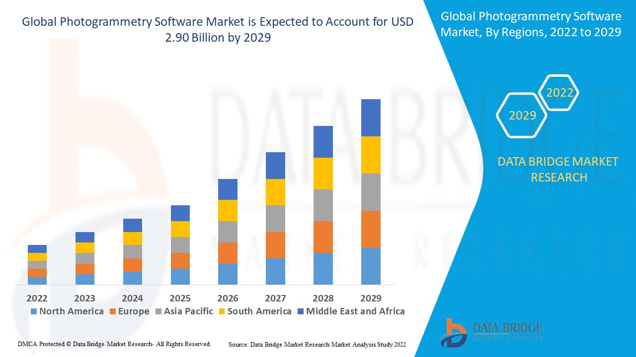
写真測量ソフトウェアの世界市場規模は、2024年に15億3,000万米ドルと評価され、2025年から2032年の予測期間中に13.66%のCAGRで成長し、2032年には42億6,000万米ドルに達すると予測されています。市場価値、成長率、セグメンテーション、地理的範囲、主要プレーヤーなどの市場シナリオに関する洞察に加えて、Data Bridge Market Researchがまとめた市場レポートには、詳細な専門家の分析、地理的に表された企業別の生産と生産能力、販売業者とパートナーのネットワークレイアウト、詳細で最新の価格動向分析、サプライチェーンと需要の不足分析も含まれています。
写真測量ソフトウェア市場の動向
「写真測量ソフトウェアにおける AI と機械学習の採用の増加」
写真測量ソフトウェア市場における重要なトレンドは、 AIと機械学習 (ML) 技術の統合です。これらの進歩により、画像処理と分析が強化され、ソフトウェアがオブジェクトを自動的に検出して分類できるようになり、精度と効率が向上します。たとえば、Pix4D や Agisoft などの企業は、AI を組み込んで特徴抽出を自動化し、ポイント クラウド生成を改善して、マッピング プロセスを高速化しています。これらの技術は、ワークフローを最適化し、人的エラーを減らし、より詳細で正確な結果を提供します。AI と ML の採用により、写真測量が変革され、建設、農業、鉱業などの業界でよりアクセスしやすく、効率的なものになっています。
レポートの範囲と写真測量ソフトウェア市場のセグメンテーション
|
属性 |
写真測量ソフトウェアの主要市場分析 |
|
対象セグメント |
|
|
対象国 |
北米では米国、カナダ、メキシコ、ヨーロッパではドイツ、フランス、英国、オランダ、スイス、ベルギー、ロシア、イタリア、スペイン、トルコ、その他のヨーロッパ、ヨーロッパでは中国、日本、インド、韓国、シンガポール、マレーシア、オーストラリア、タイ、インドネシア、フィリピン、アジア太平洋地域 (APAC) ではその他のアジア太平洋地域 (APAC)、中東およびアフリカ (MEA) の一部としてサウジアラビア、UAE、南アフリカ、エジプト、イスラエル、中東およびアフリカ (MEA) の一部としてその他の中東およびアフリカ (MEA)、南米の一部としてブラジル、アルゼンチン、その他の南米 |
|
主要な市場プレーヤー |
Pix4D SA (スイス)、3Dflow SR (イタリア)、Agisoft (ロシア)、Capturing Reality sro (スロバキア)、Vexcel Imaging GmbH (オーストリア)、nFrames (ドイツ)、REDcatch GmbH (オーストリア)、NUBIGON Inc. (米国)、Linearis3D GmbH & Co.KG (ドイツ)、Menci software SRL (イタリア)、Photometrix Photogrammetry Software (オーストラリア)、Skyline Software Systems Inc. (米国)、Racurs (モスクワ)、SimActive Inc. (カナダ)、ICAROS (ドイツ)、Magnasoft. (インド)、DroneDeploy (米国)、PhotoModeler Technologies (カナダ)、Esri International LLC (米国)、Autodesk, Inc. (米国)、Trimble Inc. (米国)、Hexagon AB (スウェーデン) |
|
市場機会 |
|
|
付加価値データ情報セット |
データブリッジマーケットリサーチがまとめた市場レポートには、市場価値、成長率、セグメンテーション、地理的範囲、主要企業などの市場シナリオに関する洞察に加えて、専門家による詳細な分析、地理的に表された企業別の生産量と生産能力、販売業者とパートナーのネットワークレイアウト、詳細かつ最新の価格動向分析、サプライチェーンと需要の不足分析も含まれています。 |
写真測量ソフトウェア市場の定義
写真測量ソフトウェアは、写真やその他の画像から 3D モデルやマップを作成するために使用されるツールです。このソフトウェアは、さまざまな角度から撮影されたオブジェクトまたはエリアの複数の写真を分析し、アルゴリズムを使用して測定値と空間情報を抽出します。このプロセスにより、正確で高解像度の 3D モデルまたはマップが作成されます。写真測量は、測量、建築、考古学、地理情報システム (GIS) などの分野でよく使用されます。このソフトウェアは航空画像と地上画像の両方を処理できるため、地形図作成、地形モデリング、仮想現実シミュレーションなどのアプリケーションに役立ち、正確な空間データと視覚化機能を提供します。
写真測量ソフトウェア市場の動向
ドライバー
- 3Dモデリングの需要増加
3D モデリングの需要の高まりは、写真測量ソフトウェア市場の主な推進力です。建設、鉱業、ゲームなどの業界では、設計、計画、視覚化に高精度の 3D モデルが使用されています。建設業界では、写真測量によって詳細な現場モデルを作成できるため、プロジェクト計画が改善され、エラーが削減されます。鉱業では、鉱山のデジタル モデルを作成して、より安全で効率的な資源抽出を行うために使用されます。ゲーム業界では、写真測量を活用してリアルな環境とテクスチャを作成し、ユーザー エクスペリエンスを向上させています。たとえば、Battlefield V などの AAA ゲーム タイトルでは、写真測量を使用して現実世界の風景を再現し、非常に詳細な 3D モデルを作成するソフトウェアの能力を示し、さまざまな分野での市場導入をさらに促進しています。
- GIS(地理情報システム)との統合
写真測量ソフトウェアと地理情報システム (GIS) のシームレスな統合は、空間分析とデータの視覚化を強化する上で重要な役割を果たします。この統合により、都市計画、環境モニタリング、農業などの業界では、正確な 3D モデルと地理空間データに基づいてデータ主導の意思決定を行うことができます。たとえば、都市計画では、ニューヨークなどの都市が詳細なマッピングに写真測量を活用し、GIS と統合してインフラストラクチャ開発を計画し、都市のスプロール現象を監視しています。同様に、農業では、GIS 統合写真測量が土地の地形と作物の健康状態に関する洞察を提供することで精密農業に役立ち、高度なデータ分析機能で幅広い分野をサポートする写真測量ソフトウェアの成長を促進しています。
機会
- ドローン技術の進歩
The rise of drones equipped with high-resolution cameras has significantly enhanced the capabilities of photogrammetry software, creating ample market opportunities. In agriculture, drones are used for crop monitoring and field mapping, enabling farmers to optimize irrigation and detect diseases early. For surveying, drones provide fast and cost-effective aerial imagery, reducing the need for manual data collection in remote or hazardous areas. Additionally, in infrastructure inspection, drones equipped with photogrammetry software allow detailed analysis of bridges, roads, and powerlines, minimizing downtime and increasing safety. For instance, companies such as senseFly and DJI are integrating advanced drones with photogrammetry tools, driving growth in industries ranging from agriculture to construction.
- Growing Adoption in Archaeology and Heritage Preservation
Photogrammetry software has become a critical tool in archaeology and heritage preservation. It enables the creation of highly detailed 3D models of ancient monuments, sculptures, and historical sites, preserving their structure for future generations. For instance, the 3D scanning of the ancient city of Pompeii and the restoration of the Notre-Dame Cathedral in Paris have demonstrated the value of photogrammetry in maintaining cultural heritage. The ability to digitally recreate and restore historical artifacts without physical interference opens up significant opportunities in the market, especially with governments, museums, and research institutions investing in these technologies for conservation and virtual tourism experiences.
Restraints/Challenges
- High Cost of Software
The high cost of advanced photogrammetry software significantly hinders market growth. The expensive pricing of these solutions creates a barrier for small businesses, independent professionals, and startups who may lack the financial resources to invest in high-end software. As a result, many potential users are forced to opt for lower-cost or free alternatives that offer limited features, which can be inadequate for professional use. This shift toward more affordable options reduces the overall adoption of cutting-edge software and restricts its use in industries where accuracy and precision are crucial. Consequently, the high price of photogrammetry software limits its widespread implementation and impedes market expansion.
- Accuracy and Precision Limitations
Accuracy and precision limitations in photogrammetry software present a significant challenge to its adoption. In complex or obstructed environments, such as areas with poor lighting, dense vegetation, or intricate structures, the software may struggle to deliver precise results. This can lead to errors in crucial applications such as surveying, construction, and mapping, where high accuracy is essential. The resulting inaccuracies reduce the reliability of the software, diminishing user trust and hindering its widespread adoption. As these errors can impact the quality of projects and lead to costly mistakes, users may hesitate to rely on photogrammetry, ultimately limiting the market's growth and potential.
This market report provides details of new recent developments, trade regulations, import-export analysis, production analysis, value chain optimization, market share, impact of domestic and localized market players, analyses opportunities in terms of emerging revenue pockets, changes in market regulations, strategic market growth analysis, market size, category market growths, application niches and dominance, product approvals, product launches, geographic expansions, technological innovations in the market. To gain more info on the market contact Data Bridge Market Research for an Analyst Brief, our team will help you take an informed market decision to achieve market growth.
Photogrammetry Software Market Scope
The market is segmented on the basis of method, photogrammetry style, application and end user. The growth amongst these segments will help you analyze meagre growth segments in the industries and provide the users with a valuable market overview and market insights to help them make strategic decisions for identifying core market applications.
Method
- Aerial Photogrammetry
- Terrestrial Photogrammetry
- Satellite Photogrammetry
- Macro Photogrammetry
Photogrammetry Style
- Point-and-Shoot Photogrammetry
- Multi-Camera Photogrammetry
- Video-to-Photogrammetry
Application
- Culture Heritage and Museum
- Films and Games
- Topographic Maps
- Traffic Management System
- 3D Printing
- Drones and Robots
- Others
End User
- Building and Construction
- Automotive
- Energy
- Oil and Gas
- Ship Building
- Others
Photogrammetry Software Market Regional Analysis
The market is analyzed and market size insights and trends are provided by method, photogrammetry style, application and end user as referenced above.
The countries covered in the market report are U.S., Canada, Mexico in North America, Germany, Sweden, Poland, Denmark, Italy, U.K., France, Spain, Netherland, Belgium, Switzerland, Turkey, Russia, Rest of Europe in Europe, Japan, China, India, South Korea, New Zealand, Vietnam, Australia, Singapore, Malaysia, Thailand, Indonesia, Philippines, Rest of Asia-Pacific (APAC) in Asia-Pacific (APAC), Brazil, Argentina, Rest of South America as a part of South America, U.A.E, Saudi Arabia, Oman, Qatar, Kuwait, South Africa, Rest of Middle East and Africa (MEA) as a part of Middle East and Africa (MEA).
North America is expected to dominate the photogrammetry software market due to the presence of major key players and increased investment to foster business growth in the region. Companies in the U.S. and Canada are focusing on enhancing their technological capabilities, leading to innovations in photogrammetry solutions. Additionally, the rising adoption of photogrammetry in industries such as construction, defense, and agriculture is driving market growth. The increasing demand for accurate 3D mapping and modeling solutions further strengthens North America's position as the leading market, with significant contributions from both private and public sectors.
Asia-Pacific is expected to witness significant growth in the photogrammetry software market during the forecast period due to the rise in construction activities and increased initiatives for infrastructural development in the region. Countries such as China and India are investing heavily in urban planning and large-scale infrastructure projects, boosting the demand for advanced software solutions. Additionally, the region's adoption of smart city technologies and the growing interest in geospatial data analytics further propel market growth. The expanding aerospace and defense sectors are also driving the demand for photogrammetry software, creating new opportunities for market players.
The country section of the report also provides individual market impacting factors and changes in market regulation that impact the current and future trends of the market. Data points such as down-stream and upstream value chain analysis, technical trends and porter's five forces analysis, case studies are some of the pointers used to forecast the market scenario for individual countries. Also, the presence and availability of global brands and their challenges faced due to large or scarce competition from local and domestic brands, impact of domestic tariffs and trade routes are considered while providing forecast analysis of the country data.
Photogrammetry Software Market Share
The market competitive landscape provides details by competitor. Details included are company overview, company financials, revenue generated, market potential, investment in research and development, new market initiatives, global presence, production sites and facilities, production capacities, company strengths and weaknesses, product launch, product width and breadth, application dominance. The above data points provided are only related to the companies' focus related to market.
Photogrammetry Software Market Leaders Operating in the Market Are:
- Pix4D SA (Switzerland)
- 3Dflow SR (Italy)
- Agisoft (Russia)
- Capturing Reality s.r.o. (Slovakia)
- Vexcel Imaging GmbH (Austria)
- nFrames (Germany)
- REDcatch GmbH (Austria)
- NUBIGON Inc. (U.S.)
- Linearis3D GmbH & Co.KG (Germany)
- Menci software SRL (Italy)
- Photometrix Photogrammetry Software (Australia)
- Skyline Software Systems Inc. (U.S.)
- Racurs (Moscow)
- SimActive Inc. (Canada)
- イカロス(ドイツ)
- マグナソフト(インド)
- DroneDeploy(米国)
- PhotoModeler Technologies (カナダ)
- Esri International LLC (米国)
- オートデスク株式会社(米国)
- トリンブル社(米国)
- ヘキサゴンAB(スウェーデン)
写真測量ソフトウェア市場の最新動向
- 2023年3月、Skycatch EdgePlus V2.4.0のリリースでは、高精度の3Dドローン写真測量、処理、分析のためのソフトウェアの機能を強化する重要なアップデートが導入されました。このバージョンでは、鉱業や建設などの業界向けの統合の改善とパフォーマンスの向上に重点を置いたプラットフォームの改善が行われ、ユーザーはより正確な3Dモデルと地理空間データを生成できるため、高度なドローンマッピングアプリケーションに不可欠なツールとなっています。
- 2023年1月、PhotometrixはiWitnessPROバージョン4.2をリリースし、写真測量ソフトウェアの大幅なアップグレードを提供しました。このバージョンでは、完全にテクスチャ化された高解像度の3Dモデル、デジタルサーフェスモデル、3Dオブジェクトの再構築の自動生成が導入されています。高度な写真測量と高密度画像マッチング技術を活用することで、このソフトウェアは測量、エンジニアリング、建築などの業界で正確な3D視覚化を必要とするアプリケーションにさらに適したものとなり、ワークフローの効率と精度が向上します。
- 2022年12月、Pix4Dはクラウドプラットフォームに新しい機能とツールを導入し、ユーザーエクスペリエンスを向上させるための大幅なアップグレードを追加しました。このアップデートにより、大規模なデータセットの処理の改善やモデル生成の高速化など、処理機能が強化されました。これらの改善は農業、建設、鉱業などの業界に対応し、より堅牢で効率的な写真測量ソリューションをユーザーに提供し、データ処理と分析を合理化してより良い意思決定を可能にします。
- 2021年、Hexagon ABは写真測量ソフトウェア市場の有力企業であるPMS Photo Mess System AGを買収しました。この買収により、Hexagonの写真測量ソフトウェア製品が強化され、高精度の地理空間データを必要とする業界向けの高度なソリューションでポートフォリオが拡大すると期待されています。この戦略的な動きにより、革新的なセンサー、ソフトウェア、自律技術の提供におけるHexagonの地位が強化され、最先端の写真測量ツールをより広範な技術エコシステムに統合することが容易になります。
SKU-
世界初のマーケットインテリジェンスクラウドに関するレポートにオンラインでアクセスする
- インタラクティブなデータ分析ダッシュボード
- 成長の可能性が高い機会のための企業分析ダッシュボード
- カスタマイズとクエリのためのリサーチアナリストアクセス
- インタラクティブなダッシュボードによる競合分析
- 最新ニュース、更新情報、トレンド分析
- 包括的な競合追跡のためのベンチマーク分析のパワーを活用
調査方法
データ収集と基準年分析は、大規模なサンプル サイズのデータ収集モジュールを使用して行われます。この段階では、さまざまなソースと戦略を通じて市場情報または関連データを取得します。過去に取得したすべてのデータを事前に調査および計画することも含まれます。また、さまざまな情報ソース間で見られる情報の不一致の調査も含まれます。市場データは、市場統計モデルと一貫性モデルを使用して分析および推定されます。また、市場シェア分析と主要トレンド分析は、市場レポートの主要な成功要因です。詳細については、アナリストへの電話をリクエストするか、お問い合わせをドロップダウンしてください。
DBMR 調査チームが使用する主要な調査方法は、データ マイニング、データ変数が市場に与える影響の分析、および一次 (業界の専門家) 検証を含むデータ三角測量です。データ モデルには、ベンダー ポジショニング グリッド、市場タイムライン分析、市場概要とガイド、企業ポジショニング グリッド、特許分析、価格分析、企業市場シェア分析、測定基準、グローバルと地域、ベンダー シェア分析が含まれます。調査方法について詳しくは、お問い合わせフォームから当社の業界専門家にご相談ください。
カスタマイズ可能
Data Bridge Market Research は、高度な形成的調査のリーダーです。当社は、既存および新規のお客様に、お客様の目標に合致し、それに適したデータと分析を提供することに誇りを持っています。レポートは、対象ブランドの価格動向分析、追加国の市場理解 (国のリストをお問い合わせください)、臨床試験結果データ、文献レビュー、リファービッシュ市場および製品ベース分析を含めるようにカスタマイズできます。対象競合他社の市場分析は、技術ベースの分析から市場ポートフォリオ戦略まで分析できます。必要な競合他社のデータを、必要な形式とデータ スタイルでいくつでも追加できます。当社のアナリスト チームは、粗い生の Excel ファイル ピボット テーブル (ファクト ブック) でデータを提供したり、レポートで利用可能なデータ セットからプレゼンテーションを作成するお手伝いをしたりすることもできます。