Press Release

Aug, 30 2024

Increased use of Drones, Satellite Imaging, and Advanced Sensors for Detailed and Accurate Agricultural Mapping is driving the growth of Global Agricultural Mapping and Imaging Market

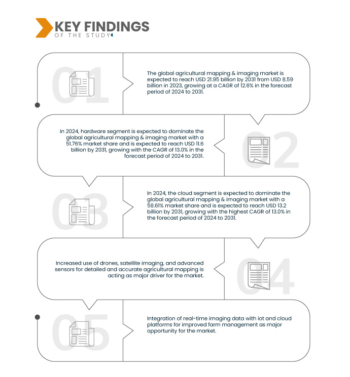
The increased use of drones, satellite imaging, and advanced sensors has revolutionized agricultural mapping and imaging by providing detailed and accurate data essential for precision farming. Drones equipped with multispectral and hyperspectral cameras can capture high-resolution images of crops, allowing farmers to monitor plant health, identify pest infestations, and optimize irrigation practices. Satellite imaging offers large-scale coverage and frequent updates, enabling the tracking of crop growth, soil moisture levels, and the impacts of climate change over vast areas. Advanced sensors, integrated with Internet of Things (IoT) technology, provide real-time data on soil conditions, weather patterns, and crop status, facilitating timely decision-making. Together, these technologies enhances productivity, reduce resource wastage, and even promote sustainable agricultural practices, ensuring better yields and environmental stewardship.

Access Full Report @ https://www.databridgemarketresearch.com/jp/reports/global-agricultural-mapping-and-imaging-market

Data Bridge Market Research analyses that the Agricultural Mapping and Imaging Market is expected to reach USD 21.95 billion by 2031 from USD 8.59 billion in 2024, growing with a CAGR of 12.6% in the forecast period of 2024 to 2031.

Key Findings of the Study

Agricultural Mapping and Imaging Market

Growing Adoption of Precision Agriculture Techniques

The growing adoption of precision agriculture techniques, supported by advancements in agricultural mapping and imaging technologies, is revolutionizing farming practices. Precision agriculture utilizes detailed data from drones, satellite imaging, and advanced sensors to tailor farming activities such as irrigation, fertilization, and pest management to specific field conditions. As precision agriculture continues to gain traction, the demand for sophisticated mapping and imaging solutions in agriculture is expected to rise, driving innovation and investment in the agricultural mapping & imaging sector.

Report Scope and Market Segmentation

Report Metric

Details

Forecast Period

2024 to 2031

Base Year

2023

Historic Years

2022 (Customizable from 2016-2021)

Quantitative Units

Revenue in USD Billion

Segments Covered

Offering (Hardware, Software, Services), Autonomy (Semi-Autonomous, Manual, Autonomous), Deployment Mode (Cloud, On-Premise), Application (Crop Health Monitoring, Field Mapping, Yield Monitoring, Weather Monitoring & Forecasting, Water Management), End User (Farms, Agro-Tech Companies, Research Institutes, and Agrochemical Companies)

Countries Covered

U.S., Canada, Mexico, China, Japan, India, South Korea, Australia & New Zealand, Singapore, Malaysia, Thailand, Indonesia, Philippines, Taiwan, Vietnam, rest of Asia-Pacific, U.K., Germany, France, Italy, Spain, Russia, Netherlands, Switzerland, Sweden, Belgium, Denmark, Poland, Norway, Turkey, Finland, Rest of Europe, Saudi Arabia, South Africa, U.A.E., Israel, Egypt, Qatar, Oman, Kuwait, Bahrain, rest of Middle East and Africa, Brazil, Argentina, rest of South America

Market Players Covered

Yara (Norway), AGCO Corporation (U.S.), Corteva (U.S.), CNH Industrial N.V. (U.K.), Trimble Inc. (U.S.), Syngenta (Switzerland), Bayer AG (Germany), Raven Industries, Inc. (U.S.), DJI (China), Cargill, Incorporated (U.S.), YANMAR HOLDINGS CO., LTD. (Japan), Yamaha Motor Co., Ltd. (Japan), Semios (Canada), Farmwise (U.S.), Sentera (U.S.), ESRI (U.S.), METER Group (U.S.), Climate LLC. (U.S.), HUMMINGBIRD TECHNOLOGIES LIMITED (U.K.), HIPHEN (France), Satellite Imaging Corporation (U.S.), and AGRICOLUS (Italy) among others

Data Points Covered in the Report

In addition to the market insights such as market value, growth rate, market segments, geographical coverage, market players, and market scenario, the market report curated by the Data Bridge Market Research team includes in-depth expert analysis, import/export analysis, pricing analysis, production consumption analysis, and pestle analysis.

Segment Analysis

Agricultural mapping & imaging market is segmented into five notable segments, which is based on offering, autonomy, deployment mode, application, and end user.

  • On the basis of offering, the agricultural mapping & imaging market is segmented into hardware, software, and services

In 2024, the hardware segment is expected to dominate the agricultural mapping & imaging market

In 2024, the hardware segment is expected to dominate the market with a market share of 51.76% due to the essential nature of physical devices such as drones, sensors, and imaging equipment. These hardware components are foundational to capturing accurate data, which forms the basis for advanced mapping and imaging solutions in agriculture.

  • On the basis of autonomy, the agricultural mapping & imaging market is segmented into semi-autonomous, manual, and autonomous

 In 2024, the semi-autonomous segment is expected to dominate the agricultural mapping & imaging market

In 2024, the semi-autonomous segment is expected to dominate the agricultural mapping & imaging market with a market share of 49.00% due to integration of real-time imaging data with IoT and cloud platforms.

  • On the basis of deployment mode, the agricultural mapping & imaging market is segmented into cloud, and on-premise. In 2024, the cloud segment is expected to dominate the agricultural mapping & imaging market with a market share of 58.61%
  • On the basis of application, the agricultural mapping & imaging market is segmented into crop health monitoring, field mapping, yield monitoring, weather monitoring and forecasting, water management, and others. In 2024, crop health monitoring segment is expected to dominate the agricultural mapping & imaging market with a market share of 31.80% 
  • On the basis of end user, the agricultural mapping & imaging market is segmented into agricultural mapping & imaging market is segmented into farms, agro-tech companies, research institutes, agrochemical companies, and others. In 2024, farms segment is expected to dominate the agricultural mapping & imaging market with a market share of 43.87%

Major Players

Data Bridge Market Research analyzes Yara (Norway), AGCO Corporation (U.S.), Corteva (U.S.), CNH Industrial N.V. (U.K.), and Trimble Inc (U.S.) as the major companies operating in the agricultural mapping & imaging market.

Agricultural Mapping and Imaging Market

Market Development

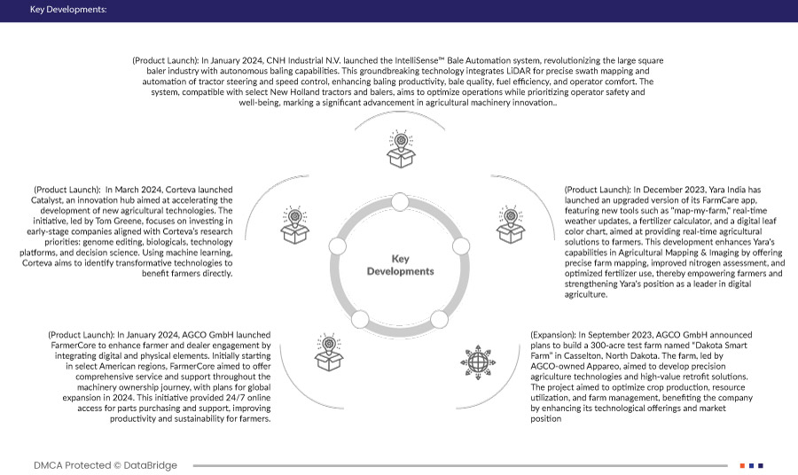
  • In March 2024, Corteva launched Catalyst, an innovation hub aimed at accelerating the development of new agricultural technologies. The initiative, led by Tom Greene, focuses on investing in early-stage companies aligned with Corteva’s research priorities: genome editing, biologicals, technology platforms, and decision science. Using machine learning, Corteva aims to identify transformative technologies to benefit farmers directly
  • In January 2024, AGCO GmbH launched FarmerCore to enhance farmer and dealer engagement by integrating digital and physical elements. Initially starting in select American regions, FarmerCore aimed to offer comprehensive service and support throughout the machinery ownership journey, with plans for global expansion in 2024. This initiative provided 24/7 online access for parts purchasing and support, improving productivity and sustainability for farmers
  • In December 2023, Yara India has launched an upgraded version of its FarmCare app, featuring new tools such as "map-my-farm," real-time weather updates, a fertilizer calculator, and a digital leaf color chart, aimed at providing real-time agricultural solutions to farmers. This development enhances Yara's capabilities in Agricultural Mapping & Imaging by offering precise farm mapping, improved nitrogen assessment, and optimized fertilizer use, thereby empowering farmers and strengthening Yara's position as a leader in digital agriculture
  • In September 2023, AGCO GmbH announced plans to build a 300-acre test farm named “Dakota Smart Farm” in Casselton, North Dakota. The farm, led by AGCO-owned Appareo, aimed to develop precision agriculture technologies and high-value retrofit solutions. The project aimed to optimize crop production, resource utilization, and farm management, benefiting the company by enhancing its technological offerings and market position
  • In January 2024, CNH Industrial N.V. launched the IntelliSense™ Bale Automation system, revolutionizing the large square baler industry with autonomous baling capabilities. This ground-breaking technology integrates LiDAR for precise swath mapping and automation of tractor steering and speed control, enhancing baling productivity, bale quality, fuel efficiency, and operator comfort. The system, compatible with select New Holland tractors and balers, aims to optimize operations while prioritizing operator safety and well-being, marking a significant advancement in agricultural machinery innovation

Regional Analysis

Geographically, the countries covered in the global virtual infrastructure manager market report are U.S., Canada, Mexico, China, Japan, India, South Korea, Australia & New Zealand, Singapore, Malaysia, Thailand, Indonesia, Philippines, Taiwan, Vietnam, rest of Asia-Pacific, Italy, France, Germany, Spain, Poland, Netherlands, Romania, Denmark, Belgium, Greece, Hungary, Portugal, Ireland, Austria, Czechia, Sweden, Bulgaria, Finland, Croatia, Lithuania, Slovenia, Latvia, Slovakia, Cyprus, Estonia, Luxembourg, Malta, Non-EU Europe, Saudi Arabia, South Africa, Egypt, Bahrain, Oman, Israel, Kuwait, Qatar, U.A.E., Rest of Middle East and Africa, Brazil, Argentina, Mexico, and rest of Latin America.

As per Data Bridge Market Research analysis:

North America is expected to dominate and be the fastest growing region in the agricultural mapping & imaging market  

North America is expected to dominate the market due to its advanced agricultural practices, extensive adoption of precision farming technologies, robust infrastructure supporting IoT and cloud computing, and significant investments in agricultural research and development. These factors collectively enhance the region's capability to integrate sophisticated mapping and imaging solutions effectively, driving higher adoption rates and market leadership in agricultural technology innovation.

In the agriculture mapping and imaging market, the U.S. dominates in North America due to advanced technological adoption and strong investment in precision agriculture. In Europe, Italy leads with its extensive agricultural practices and government support for modern farming techniques. In Asia-Pacific, China is at the forefront, driven by its large-scale agricultural activities and rapid advancements in agri-tech innovations.

For more detailed information about Global Agricultural Mapping & Imaging market report, click here – https://www.databridgemarketresearch.com/jp/reports/global-agricultural-mapping-and-imaging-market

Client Testimonials