Global Geographic Information System Gis Market
Market Size in USD Billion
CAGR :
% 
 USD
9,270.20 Billion
USD
23,518.33 Billion
2022
2030
USD
9,270.20 Billion
USD
23,518.33 Billion
2022
2030
| 2023 –2030 | |
| USD 9,270.20 Billion | |
| USD 23,518.33 Billion | |
|
|
|
|

Geographic Information System (GIS) Market Analysis and Size
The global geographic information system (GIS) market is segmented on the basis of component, function, and end user. The growth among segments helps you analyse niche pockets of growth and strategies to approach the market and determine your core application areas and the difference in your target markets.
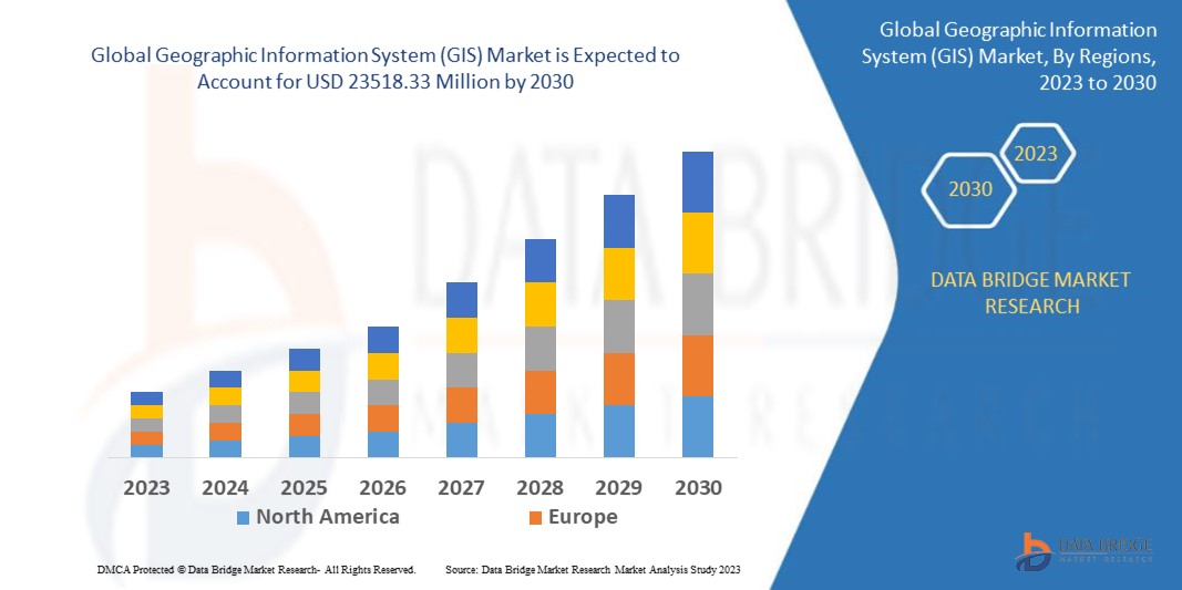
Data Bridge Market Research analyses that the global geographic information system (GIS) market which was USD 9270.2 million in 2022, would rocket up to USD 23518.33 million by 2030, and is expected to undergo a CAGR of 11.90% during the forecast period. This indicates the market value. “Hardware” is expected to dominate the type segment of the global geographic information system (GIS) market due to their sports and fitness segment is expected to dominate the market as due to continuous increasing adoption of wearable electronic devices for sports and fitness in the order to enhanced sports, fitness, and well-being by monitoring physiological conditions of wearers. In addition to the market insights such as market value, growth rate, market segments, geographical coverage, market players, and market scenario, the market report curated by the Data Bridge Market Research team includes in-depth expert analysis, import/export analysis, pricing analysis, production consumption analysis, and pestle analysis.
Geographic Information System (GIS) Market Scope and Segmentation
|
Report Metric |
Details |
|
Forecast Period |
2023 to 2030 |
|
Base Year |
2022 |
|
Historic Years |
2021 (Customizable to 2015-2020) |
|
Quantitative Units |
Revenue in USD Million, Volumes in Units, Pricing in USD |
|
Segments Covered |
Component (Hardware, Software), Function (Mapping, Surveying, Telematics Navigation, Location Based Services), End User (Agriculture, Oil and Gas, Construction, Mining, Transportation, Utilities, Others)), |
|
Countries Covered |
U.S., Canada and Mexico in North America, Germany, France, U.K., Netherlands, Switzerland, Belgium, Russia, Italy, Spain, Turkey, Rest of Europe in Europe, China, Japan, India, South Korea, Singapore, Malaysia, Australia, Thailand, Indonesia, Philippines, Rest of Asia-Pacific (APAC) in the Asia-Pacific (APAC), Saudi Arabia, U.A.E, Israel, Egypt, South Africa, Rest of Middle East and Africa (MEA) as a part of Middle East and Africa (MEA), Brazil, Argentina and Rest of South America as part of South America |
|
Market Players Covered |
Environmental Systems Research Institute, Inc. (Esri) (U.S.), Hexagon (Sweden), Pitney Bowes Inc. (U.S.), Autodesk Inc. (U.S.), Trimble Inc. (U.S.), Topcon (Japan), Hi-Target. (China), BENTLEY SYSTEMS, INCORPORATED (U.S.), Caliper Corporation (U.S.), Computer Aided Development Corporation Limited (Cadcorp) (U.K.), SuperMap Software Co., Ltd. (China), L3Harris Technologies, Inc. (U.S.), and Maxar Technologies (U.S.). |
|
Market Opportunities |
|
Market Definition
A software application called geographic information is used to evaluate, produce, maintain, and map various sorts of data. By combining location data with various descriptive data types, such as demographic data, it also connects to the map. Analyzing, interpreting, and visualizing geographic data to identify trends, patterns, and relevant investments is now possible thanks to technology. Users can better understand relationships, trends, and spatial context via GIS. Recently, mapping has become this technology's most significant role.
Global Geographic Information System (GIS) Dynamics
Drivers
- Development of Smart Cities and Modern Urban Planning
The process of site selection, land acquisition, planning, designing, visualizing, building, project management, operations, and reporting are all aided by geographic information system (GIS) software for smart cities. The geographic information system (GIS) solutions are used in urban planning by experts to better properly analyze, model, and visualize places. By processing geospatial data from satellite imaging, aerial photography, and remote sensors, geographic information system (GIS) software systems offer a comprehensive perspective of the land and infrastructure. The industry for geographic information system software is growing over the forecast period as a result of such geographic information system (GIS) software application.
- Development Of Smart Cities and Modern Urban Planning
The process of site selection, land acquisition, planning, designing, visualizing, building, project management, operations, and reporting are all aided by geographic information system (GIS) software for smart cities. The geographic information system (GIS) solutions are used in urban planning by experts to better properly analyze, model, and visualize places. By processing geospatial data from satellite imaging, aerial photography, and remote sensors, geographic information system (GIS) software systems offer a comprehensive perspective of the land and infrastructure. The industry for geographic information system software is growing over the forecast period as a result of such geographic information system (GIS) software application.
Opportunities
- Integration Of Artificial Intelligence (AI)
The integration of artificial intelligence (AI) with geographic information system (GIS) is estimated to generate lucrative opportunities for the market, which will further expand the market's growth rate. Major players are combining GIS with artificial intelligence (AI) due to technological improvements. For instance, the emergence of geospatial artificial intelligence (GeoAI), which employs AI to extract information from geographical big data, has aided governments in the creation of smart cities, the planning of urban infrastructure, and the monitoring of changes over time in a given area.
- Integration Of Internet of Things (IoT)
Additionally, the integration of internet of things (IoT) with geographic information system (GIS) also further offer numerous growth opportunities within the market. Real-time location data are being produced as a result of the internet of things (IoT) platforms' increasing use in business operations to provide customers with highly relevant and location-specific services. Additionally, the combination of geographic information system (GIS) and internet of things (IoT) devices gives users access to accurate data for geospatial data analysis. For instance, geographical data can be used to monitor an IoT-enabled valve from any location in the world
Restraints/Challenges
- High Cost
The pricey geographic information system will further derail the overall market’s growth. The geographic information system (GIS) is expensive because in addition to the technology and software, it is necessary to have a properly qualified human workforce. Specialized knowledge is needed to comprehend and interpret the information gathered by a geographic information system (GIS) system, which is expensive to hire and train. This factor will therefore obstruct market growth over the forecast period.
Recent Development
- In June 2022, Hexagon, a multibillion-dollar market leader in sensor, software, and digital reality solutions, is supporting start-ups to boost productivity and ESG. Hexagon Manufacturing Intelligence Division awarded SmartParts and RIIICO recognition. The manufacturing sector's efficiency and sustainability will rise thanks to the open innovation platform's assistance in scaling startups and expanding connectivity with top-tier businesses.
- In June 2022, Construct Helix was introduced by Bentley Acceleration Initiatives, the company's internal incubator for strategic investments. Bentley Systems is a provider of infrastructure engineering software. By offering SaaS solutions that will enable a connected data environment, it is specifically designed to digitalize the flow of construction project workflows.
Global Geographic Information System (GIS) Scope
The geographic information system (GIS) market is segmented on the basis of component, function and end-user. The growth amongst these segments will help you analyze meagre growth segments in the industries and provide the users with a valuable market overview and market insights to help them make strategic decisions for identifying core market applications.
Component
- Hardware
- GIS collectors
- Imaging sensors
- LiDAR
- Total stations
- GNSS/GPS Antennas
- Software
- Desktop GIS
- Server GIS
- Developer GIS
- Mobile GIS
- Remote Sensing Software
Function
- Mapping
- Surveying
- Telematics Navigation
- Location Based Services
End-User
- Agriculture
- Oil and Gas
- Construction
- Mining
- Transportation
- Utilities
- others
Global Geographic Information System (GIS) Market Regional Analysis/Insights
The countries covered in the geographic information system (GIS) market report are U.S., Canada and Mexico in North America, Germany, France, U.K., Netherlands, Switzerland, Belgium, Russia, Italy, Spain, Turkey, Rest of Europe in Europe, China, Japan, India, South Korea, Singapore, Malaysia, Australia, Thailand, Indonesia, Philippines, Rest of Asia-Pacific (APAC) in the Asia-Pacific (APAC), Saudi Arabia, U.A.E, Israel, Egypt, South Africa, Rest of Middle East and Africa (MEA) as a part of Middle East and Africa (MEA), Brazil, Argentina and Rest of South America as part of South America.
North America dominates the geographic information system (GIS) market because of the high rate of adoption of geographic information system (GIS) technology within the region over the forecast period of 2022 to 2029. Moreover, the increased research and development proficiencies to improve the technology is further estimated to accelerate the expansion over the forecast period.
Asia-Pacific is expected to witness significant growth during the forecast period of 2022 to 2029 due to rapid urbanization and construction of smart cities within the region. The increasing awareness about the geographic information system (GIS) technology is a significant contributor to the regional market expansion.
The country section of the report also provides individual market impacting factors and changes in regulation in the market domestically that impacts the current and future trends of the market. Data points like down-stream and upstream value chain analysis, technical trends and porter's five forces analysis, case studies are some of the pointers used to forecast the market scenario for individual countries. Also, the presence and availability of global brands and their challenges faced due to large or scarce competition from local and domestic brands, impact of domestic tariffs and trade routes are considered while providing forecast analysis of the country data.
Competitive Landscape and Global Augmented Reality Market Share Analysis
The market competitive landscape provides details by competitor. Details included are company overview, company financials, revenue generated, market potential, investment in research and development, new market initiatives, North America presence, production sites and facilities, production capacities, company strengths and weaknesses, product launch, product width and breadth, and application dominance. The above data points provided are only related to the companies focus related to global geographic information system (GIS) market.
Some of the major players operating in the global geographic information system (GIS) market are:
Environmental Systems Research Institute, Inc. (Esri) (U.S.), Hexagon (Sweden), Pitney Bowes Inc. (U.S.), Autodesk Inc. (U.S.), Trimble Inc. (U.S.), Topcon (Japan), Hi-Target. (China), BENTLEY SYSTEMS, INCORPORATED (U.S.), Caliper Corporation (U.S.), Computer Aided Development Corporation Limited (Cadcorp) (U.K.), SuperMap Software Co., Ltd. (China), L3Harris Technologies, Inc. (U.S.), and Maxar Technologies (U.S.)
SKU-
Get online access to the report on the World's First Market Intelligence Cloud
- Interactive Data Analysis Dashboard
- Company Analysis Dashboard for high growth potential opportunities
- Research Analyst Access for customization & queries
- Competitor Analysis with Interactive dashboard
- Latest News, Updates & Trend analysis
- Harness the Power of Benchmark Analysis for Comprehensive Competitor Tracking
Research Methodology
Data collection and base year analysis are done using data collection modules with large sample sizes. The stage includes obtaining market information or related data through various sources and strategies. It includes examining and planning all the data acquired from the past in advance. It likewise envelops the examination of information inconsistencies seen across different information sources. The market data is analysed and estimated using market statistical and coherent models. Also, market share analysis and key trend analysis are the major success factors in the market report. To know more, please request an analyst call or drop down your inquiry.
The key research methodology used by DBMR research team is data triangulation which involves data mining, analysis of the impact of data variables on the market and primary (industry expert) validation. Data models include Vendor Positioning Grid, Market Time Line Analysis, Market Overview and Guide, Company Positioning Grid, Patent Analysis, Pricing Analysis, Company Market Share Analysis, Standards of Measurement, Global versus Regional and Vendor Share Analysis. To know more about the research methodology, drop in an inquiry to speak to our industry experts.
Customization Available
Data Bridge Market Research is a leader in advanced formative research. We take pride in servicing our existing and new customers with data and analysis that match and suits their goal. The report can be customized to include price trend analysis of target brands understanding the market for additional countries (ask for the list of countries), clinical trial results data, literature review, refurbished market and product base analysis. Market analysis of target competitors can be analyzed from technology-based analysis to market portfolio strategies. We can add as many competitors that you require data about in the format and data style you are looking for. Our team of analysts can also provide you data in crude raw excel files pivot tables (Fact book) or can assist you in creating presentations from the data sets available in the report.


